Listen to the Land (Historical Geography) - Lesson 16
Acco Plain
Upper and Lower Galilee have the climate soil that is conducive to widespread agriculture. Lower Galilee also has some valleys that became major roads. Major empires of the fertile crescent exerted their influence here as they expanded. When the Greeks took control with their military, they also spread their cultural influence.

Acco Plain
I. Acco Plain
II. Upper and Lower Galilee
III. Lower Galilee
A. Terrain and climate
B. Roads
C. Valleys
D. Galilee of the gentiles
- 0% Complete
The land influences the people that are living on it by affecting their stories. Learning to listen to the land helps you understand the details that are hiding in the background so that when you read the Bible, it’s like you see the narrative in living color and 3 dimensions.
0% Complete - 0% Complete
Major rivers in the Ancient Near East provided the resources necessary for empires like Egypt, Assyria, Babylon and Persia to grow and flourish. Israel is on a couple of the major trade routes that connects these cultures. The location of mountains, hills and valleys in Israel affects the lifestyle and travel patterns of the people who live there and the people travelling through.
0% Complete - 0% CompleteLearn how the geography and climate of the Cisjordan and Transjordan regions shape agricultural and shepherding activities, emphasizing the importance of rain patterns and water management techniques in biblical times.0% Complete
- 0% CompleteLearn how the granite, sandstone, and three types of limestone shape the lifestyle, agriculture, and building practices in the biblical lands, highlighting the geological factors that influence whether inhabitants are migratory or sedentary.0% Complete
- 0% Complete
Bashan is in the north and has enough rainfall and arable soil to support crops and large animals like cattle. The Dome of Gilead provides connection points for international and local travel. Ammon and Moab are neighbors and descendants of Lot’s daughters. Edom is south and are descendants of Esau.
0% Complete - 0% Complete
The people that migrated to live in the coastal plain were known as the Philistines. Because of the location and terrain, the roads were sources of international travel and trade. Cities were built for commerce and control. The Negev was an important area to control for travel.
0% Complete - 0% Complete
The Rift Valley is valuable because of its location and resources. Bitumen and Balsam were sought after. It was a popular trade route but it was important to know where to get water. Jericho was at crossroads and was near some major springs. Connecting events in biblical history to the event and location of the baptism of Jesus adds weight and significance to it.
0% Complete - 0% Complete
The hill country of Judah has enough rain to grow grapes and other crops. Hebron was first given to Caleb and then was the city that David ruled from when he first became king. It was a connecting point for local roads. Bethlehem and Tekoa are also cities in this area.
0% Complete - 0% Complete
Jerusalem is framed by the hills and valleys that are near it. The Sorek Wadi System is to the west and the Mount of Olives is to the east. David built a palace and Solomon later built a temple. Jerusalem was important in Jewish history and also has a place in eschatology.
0% Complete - 0% Complete
By the beginning of the first century, Jerusalem was the site of a magnificent Jewish temple built by Herod the great. He also built an impressive palace and a Roman fort which overlooked the temple. The events leading up to the crucifixion of Jesus take on added layers of meaning when you understand how the geography of the events reminded people of Messianic prophecies.
0% Complete - 0% Complete
Benjamin has the smallest tribal allotment but it is one of the most significant areas in the nation of Israel. The geographical features, the cities located there and the roads that run through it make it a region of national and international importance.
0% Complete - 0% Complete
The Shephelah is between the hill country and the coastal plain and has unique geographical features. When you know the location of the roads, valleys and cities in this area, you can see their significance in the stories. When you understand where Micah and Isaiah came from and their historical context, you can understand why there is a difference in their message and tone.
0% Complete - 0% Complete
The rocks and roads will give you valuable information about the Sharon Plain and Mt. Carmel. The international road took different paths around Mt. Carmel depending on your final destination. The harbor and palace that Herod built in Caesarea were impressive.
0% Complete - 0% Complete
The hill country of Joseph has abundant resources and nearby roads for commerce. Shiloh was a religious center and the place where Joshua met with representatives from each tribe to determine their tribal allotment. The women of Shiloh also were instrumental in saving the tribe of Benjamin. Shechem was important as far back as Abraham. Every time people would see Mt. Gerizim and Mt. Ebal, it was a reminder of the blessings and curses of their covenant with God.
0% Complete - 0% Complete
Who was Omri, and why was he significant in making Samaria an important city? When the people of Judah returned from Persia, there was a conflict with the people of Samaria. The animosity that was still present during the ministry of Jesus set the stage for an encounter he had with a woman that was at a well near the city.
0% Complete - 0% Complete
Upper and Lower Galilee have the climate soil that is conducive to widespread agriculture. Lower Galilee also has some valleys that became major roads. Major empires of the fertile crescent exerted their influence here as they expanded. When the Greeks took control with their military, they also spread their cultural influence.
0% Complete - 0% Complete
The Jezreel Valley is the center of activity for many of the biblical narratives. Not only was it an important economic and strategic location for Israel, but also for the Canaanites, Egyptians, Arameans and Assyrians. It is also a place where significant events took place in the lives of the prophets and Jesus.
0% Complete - 0% Complete
This body of water is often referred to as a, “sea” even though it is fresh water, not salt water. There are not many stories in the Hebrew Bible that take place in this area, but it is a center of activity for Jesus during his ministry. Many of the parables are illustrations taken from local culture and geography.
0% Complete - 0% Complete
The Huleh basin has an abundance of water from several sources. The soil is also good, but the conditions for growing crops in some areas presents some challenges. Dan is a strategic city in the north as a gateway to the region and a religious center under Jeroboam. Caesarea Phillippi was built by Herod and was a place that Jesus used to teach his disciples about his role as Messiah and their future as leaders of the church.
0% Complete - 0% Complete
The Gospel of Luke traces the journey of Jesus to Jerusalem, and the book of Acts traces the journey of the gospel going out from Jerusalem. The events in Pentecost have a connection to the events at Mt. Sinai. The gospel is for the world but the events that made it possible are anchored in Israel. (Don't forget the Epilogue, Lesson 21!)
0% Complete - 0% Complete
There are two different stories in the Gospels of Jesus feeding large groups of people. One account is in John 6 and another account is in Mark 8. The message is similar but the geography gives you some clues to help you understand why the details are different.
0% Complete
Have you ever read about a place and when you went there in person, it came alive? As you walk through the hills and valleys of Israel with Dr. Parker, you will see the stories of the Bible in living color.
Your location affects your lifestyle, relationships, worldview, occupation, diet and travel. In ancient Israel, you depended on the resources around you to survive. People often lived near springs or rivers, but it was possible in some places to collect rain water and ration it through the year. The terrain and the type of soil would determine what crops you could grow, or what animals you could raise. Living near a road would give you opportunities to sell what you produced or buy what you needed. Your location would determine the amount of risk you would face from people in neighboring countries. By living in the hill country, you would develop a different mindset than if you lived on an open plain.
Once you begin to have an understanding of the, "rocks and roads" of Israel, reading your Bible with a good map next to you will help you get a 3 dimensional perspective. When the characters and the scenery become life-like in your mind, you will find yourself being inspired and motivated in your understanding of your relationship with God and how you can apply it in your interactions with others. Take this opportunity to learn from Dr. Parker to "Listen to the Land!"
Recommended Reading:
Encountering Jesus in the Real World of the Gospels, by Dr. Cyndi Parker
Holman Illustrated Guide to Biblical Geography, by Paul Wright
Satellite Bible Atlas: Historical Geography of the Bible
Recommended Books
Listen to the Land: Historical Geography - Bible Study
Have you ever read about a place and when you went there in person, it came alive? As you walk through the hills and valleys of Israel with Dr. Parker, you will see the...
Satellite Bible Atlas
A comprehensive guide to biblical geography, The Satellite Bible Atlas by William Schlegel provides historical context and insightful maps to help readers better understand the world of the Bible.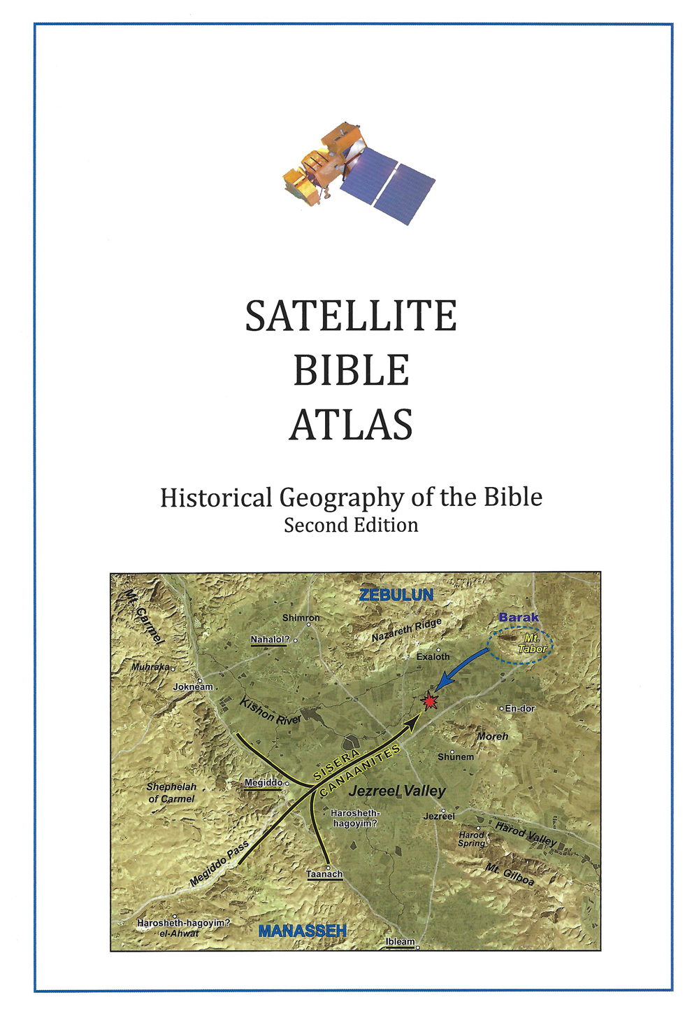
Links
Downloads
Dr. Cyndi Parker
Listen to the Land (Historical Geography)
bs600-16
Acco Plain
Lesson Transcript
All right. We are actually moving in another big section or into a new big section. So we've done the southern arena, which was all kinds of complex. The central arena, which had a little bit of variety, but not as massively crazy geologically as we saw in the South. Now we're moving to the north. And before we really go into the variety of areas that we see in the north, let's do our famous review. This is our little self testing. No pressure because there's no grades being given. But let's just see if you can remember these names, because this is always going to help you from here on out. If you can just put this into your mind, learn to see it on the maps you have in front of you. As you read the Bible stories, you're going to start to see the flow and the movement between these places. Okay, so we started up north in the Transjordan, so we have the shrine, right? And this was covered with all that volcanic activity. So we have the basalt kind of solid rock that is up on top. We have our dome of Gilad here that's cut in half by the Dabiq River. And although there's a variety in the rocks that are visible, we're going to give this mainly a cinnamon in color green. That's a really good terra rossa soil there. Amman, kind of nestled in behind our Misha or the plateau. And the plateau along with Moab, that is just south of it, has the snow and rock with the resinous soil. So we get primarily shepherding activities over here, maybe some agriculture on the raised ledge where we're getting more water. And then when we move over into our southern arena where we spent a long time in the previous days, we have the Philistine Coastal Plain. We have our biblical Negev with the less soil and really early patriarchal stories happening here. Enviable territory, not because of its rocks and soil and resources, but because of the trade connection that it facilitates. So we have the Judean wilderness, we have the riverside section of the Rift Valley. We looked all the way up the Dead Sea, the Judean Hill country, and our Shayla. And then, of course, we just came out of our our House of Joseph area, where the middle part, the big block here is Santo Manian, which gives us all kinds of resources. We're picking up more rain because we're a little bit further north. And then because of the variety of rocks that are up here in the north along Mount Carmel, it breaks up the territory a bit and it creates some big, wide open valleys and plains, which gives us all kinds of access roads heading off in all kinds of directions. Now, once we move out of this territory and we start focusing on our northern arena, now we get a whole variety of geography again. So we're going to break it up into little bite size pieces. As we look at it, we can just see how distinct everything is in this area. We no longer have our one block of hill that's going north, south. I mean, we traveled the spine of this hill country almost as much as our patriarchs did before us. When we get up into the Galilee. That underlying rock has been fragmented a lot. We have to jump all the way up into this phenomenon in Upper Galilee to find anything similar to what we had down in the South. So there's a lot of variety going on and we're going to look at each of these little bits, all of these areas individually. We're going to keep in mind, because we are now purposely, for the first time looking at our great East-West connection here, the Jezreel Valley, Harrowed Valley. We've been looking at it, we've been alluding to it. We sort of passed through the Mount Carmel range to it, but we have stopped at its edge and now we finally get to dove in and say, why is this such a significant place and what kind of stories happened here? Okay. We're going to start over on the Mediterranean, as is our custom. We're going to look at the Argo plane. And as we look at the map and where we see the Mediterranean Sea, I'm going to call the Arco plane. Well, it's not just me, actually. I belong in great company. But I will say, for the purpose of this course, we're going to look at the Arco plane with Arco right in the middle of the plane, going all the way up to modern day what's called Roshan Negra and then going all the way south to Mount Carmel. So it's quite narrow up at the in the north and it widens out down here south of Arco. We've looked at this area, or at least we've mentioned this when we were doing big picture work because when we looked at the whole edge of the Mediterranean Sea as it as it hits the coastline on the east, it's almost all straight. Even though we said the Philistines are involved in the shipping industry, it's really the Phoenicians up here in Tire and Sidon who are known for being able to handle the wildness of the yam or of the sea. The Israelites never really did. And the Israelites don't ever really have a port except for Arco. Iveco creates this little like backwards sea shape. And so if you're looking for a natural harbor, that is the only one at your disposal. So this is the tribal allotment of Ashur, although we don't have very many stories of Ashur, so we don't get we don't get a whole lot of stories about what's going on there. They are Mediterranean facing because they have hills over here at their back. Now what's interesting is because of the way the land works and because of all the different territories we've been looking at, the Israelites are always mountain focused, they're always inland focused. Even when they can get out to the big trade, they never look out towards the Mediterranean. Dealing with water. Shipping on water was not something they were ever interested in. The Egyptians entire inside on were able to deal with water. They had a water industry, they had sailors. It is very rare for the Israelites to try to attempt something like that. They were land oriented. They want their feet on the solid surface. This shows up in some of their writings, even because the Israelites look at yam or look at sea as something that is wild, chaotic, dangerous, something that God means it needs to tame. It is something that will kill you at an instant rate. It's you can feel the fear, even in their writings and suspicion of open water. Okay. So it is narrower at the top, I said. The whole entire plane is filled with alluvial soil. We've seen that in any big valley area that has mountains around it, the alluvial soil that is washing off of the hills with rainstorms and then gathering in the valley. We have the city of Yok Nigam. I think we're going to end up reviewing this a little bit later. But when we were looking at the options for how to get through the Mount Carmel range, we said there's a pass that goes right here in between the cinnamon and rock and the Eocene rock. It comes through. There's a city of Yoakum here, which is it gives its name to this past the Yoakum pass. And if you're trying to get to Arco, this is the pass you use. And then you work your way through this little pinch of the hills, although it's still flat right there. But it's it's pinched, hemmed in just for a moment before you dump out onto the plane. We still have kirker that is adding influence to the plane. If you remember down on the Sharon plane, it was preventing that valley, that plane, from draining very well into the Mediterranean. So we still have the curb car problem, but we're able to use it. It's not it doesn't ever get as swampy as the Sharon plane got. It is another element, though, I will say, that is going to influence this plane of ago is the river that drains the Jezreel Valley. So this river is there's only one river that drains this entire huge valley. And this valley is almost completely tabletop flat, which means it's really hard for the fingers of the river to pull that water in. And so water tends to collect on the Jezreel Valley on the surface of the Jezreel Valley. But ultimately, it is going to kind of drain the water is going to be pulled out this way, find its way right at the base of Mount Carmel and dump out into the Mediterranean Sea there. So if I were to show you a picture, this would be standing in the middle part of the plane of Akko, where the city of Akko is located. And we're looking south. And so the hill that is on the horizon line, that is our very light shade of blue right there. That is Mt. Carmel poking its way into the Mediterranean. This way is when we were talking about the Sharon plane and I said the Egyptians, as they sailed north on the Mediterranean, they would call this the antelopes nose and they would they would know as soon as you see the antelopes nose breaking, the flat shoreline, you know, right behind it is then going to be your natural harbor. That's a short introduction to the plane of ago, and now we get to move into upper and lower Galilee. So these are two very distinct and very different areas of the northern part of Galilee. And as we start to work our way in, before we actually start looking at the maps, I'm going to pull in our good friend Josephus, who is our Jewish historian during the first century, because Josephus was from Galilee and Josephus loved Galilee, and you can hear it in his writings because he just talks about it in these most amazing, luscious ways. So he describes or identifies that there are two different galleries. So he says these two galleries of so great largeness and encompassed with so many nations of foreigners, have been always able to make a strong resistance on all occasions of war. For the Galilee, ends are incurred to war from their infancy. Their soil is universally rich. You're feeling like he's. He's talking about his hometown. Their soil is universally rich and fruitful and full of the plantations of trees of all sorts, insomuch that it invites the most slothful to take pains in cultivation by its fruitfulness. Right. Even the most lazy among us can't help but create something beautiful. Let's look at what he means by these to Galileo's. So the two Galileo's are separated. We could say in elevation they're really quite distinct. So we can get up to about 4000 feet in upper Galilee where you're only going to get about 2000 feet in lower Galilee. And that jump happens dramatically and instantaneously. So right here at the Bait Tuck Haram Ridge or the Beit Hut, Karam Valley, they're marking the exact same thing. The mountains immediately jump up another thousand feet. So it is a distinct ridge line on the horizon. Everything in upper Galilee, except a small portion over here that I didn't color in, which is Eocene. Everything else is Santo Manian. Now, when we look at this map, we don't actually see very many cities that are listed in Upper Galilee. It's because we don't have very much history that happens up there. It's not that people weren't there. We just don't have very much history. So in the Hebrew Bible, there's only about one or two stories that have anything to do with this terrain. We get a few more stories when we get into the entire Testament all time period and our Gospels time period and the Jewish history that develops after the destruction of Jerusalem. There's quite a bit of development that happens up here in Upper Galilee, but we just don't have that many references. So we're not going to spend a whole lot of time here because I don't have that many stories that I can tell you that take place here. We would assume based on exploring and walking through this, but we could say Upper Galilee is going to be very similar to the hills of Judea. It's just not going to have a wilderness, but it's going to have because of all the sentiment and deep V-shaped valleys, because we're so high, we are all the good things with our rules of rainfall. Right? When we get up here, we are north, we are west and we are high in elevation, which means we're getting 48 inches of rain. So forests are growing up on this big mound of snow, mainly in rock. So a significant resource place, a resource even if we don't necessarily have a lot of stories having to do with it. Now, because of the difficulty of travel through here, we also don't have very many roads and because we have so many good road options south of it, we find that the road's bent around Upper Galilee. They kind of bent around that difficult travel and they tended to just lean towards. They'd rather go ten miles out of their way and have it be easier. Then take the shorter but much harder way up and over upper Galilee. So the highest peak in Upper Galilee is called Mount Merom and it's Marom, Mount Marom, and then the waters of Merom, which are a little bit obscure to place actually on the map. These are the reference points that show up in the Bible and we see them down here in the South. So if I were to show you a picture, just to kind of drive home how quickly we move from lower Galilee to upper Galilee, although we lose it in the haze when the picture gets real big on the screen. But if you squint really hard, you can see there's a ridgeline right up here, right where the black arrow stops. It's actually touching that ridgeline. That would be Upper Galilee. That would be the Beit Tucker Ridge. Right. And then all these other hills down here, this is a lower Galilee. Now, in lower Galilee, we're going to find interesting texture, interesting hills. And this picture shows one of them in particular the horns of a team, which is what we call it now. We call it the horns because it rises up on either side. But this is actually an extinct volcanic cone. This volcanic cone which sits all by itself. We saw lots of others of them. You may remember up in Bishan, there was a whole line of them across the landscape over here in the Sister Jordan, we have one the horns of a team. And if I pull up our map again, I'll save the horns of the team are here. Well, not if they are. They are here. It's. That's not up for grabs. This particular volcanic activity is responsible for all of the basalt and basalt soil that we have down in lower Galilee, but the eastern side of lower Galilee. And so all the way down we have almost like laying a blanket on top of the ridge line. And we have these distinct ridges, four different ridges that come in an angle, and there's just basalt over all of it, which means this area right here, because basalt, if you remember, it's been a while since we've dealt with basalt because we haven't had basalt in the South at all. Basalt is one of the best building materials. It's one of the best for agricultural industry. Are grinding stones. If we can make it out of the salt, that's the best. It's the most durable of our substances. And when it does crumble into US soil, it is the richest. It's black soil and it is beautiful soil. So it is going to heavily influence the resources that come out of this portion of lower Galilee. It is also going to create for us a divide between western lower Galilee and eastern lower Galilee. It is only eastern lower Galilee that has this basalt effect. We don't have any basalt over in the other section of Lower Galilee. Okay. So let's talk a little bit more about Lower Galilee and let's talk about, well, one abundance of water. We've already seen that we're getting used to it. There is great fertility because of the mixtures of soils and because of all of that water. We have that volcanic element which is adding to their resourcefulness of this area. And we have the international roads, which is not surprising us because we already know the Jezreel, her road connection, but any other valley that is there is going to be used as a good alternative to going up and over upper Galilee. And by the time we get up here, everything has changed. We don't have any desert. There's no effects of the desert. There's no desiccated effects of the snow neon. We just have fertile territory everywhere. Who doesn't want to live in Galilee? Right. This finally you start to go. This is why Josephus loves his hometown so much, because it just doesn't have the same difficulties that we found in the South. So in the heartland, the Israelite heartland, that's where the land is super vulnerable. That's where the Israelites came in. This is where they were learning their initial lessons of faith. But once you start moving up here, oh, it's so nice and it's so dangerous. Like in the faith community, you have to learn how to deal with a lot of different elements. Lower Galilee is going to be everything between the Beit Karam Valley, the Mediterranean over on the West, the Sea of Galilee on the east, and the Mount Carmel Ridge to the south. Everything in between that is roughly or no higher than 2000 feet and then pushing down. This is that area. The whole entire area is the one that I said at the very beginning of our course. It looks to me like someone takes the palm of their hand and then squishes their fingers down on top of the mountains. So we get all these different ridges like here, here and here that are popping up, but really big valleys in between. I feel I feel a question. I feel a question coming.
Speaker 2 [00:20:41] So you have the the valleys and the rainfall. What's the temperature range in these places? Because Lower Galilee is probably different than upper because of the elevation.
Dr. Parker [00:20:52] Exactly. So my apologies to everyone watching around the world because I don't speak Celsius and like I used to, I used to a lot better when I lived here and then I've kind of forgotten. So in Fahrenheit, the temperatures would probably range between 40 degrees and 110 degrees. So it's quite a wide it never is super freezing cold, but it can be quite hot and it can be quite humid. Okay. When we're in lower Galilee, we're going to keep our eyes. In fact, I probably should have colored these blue since we've been doing blue for big international roads. So the two roads that I have drawn in here, two in particular we're going to keep our eye on, and we're going to always be looking to see which city sits on top of those roads. So starting with Argo, there is one that makes a very shallow bend through this beit in a Tofa Valley area and the Terran Valley. And then it bends. It goes right by the horns of a team, which is the double H on this map. And then we have to find an easy passage way down to the Sea of Galilee, and then, you know, you're going to stop for water here and then you're going to head straight north and then over to Aram Damascus. Or you could go from Arco, you can follow the Keyshawn River Pass into the Jezreel Valley, into the Road Valley, and then over to Gilead. So you get lots of different options. Of course, the other one I didn't drive in is the one that we keep looking at, which goes through Mount Carmel as well. Okay. So this area of lower Galilee, we can define it based on the valleys that are here. So let's look at those valleys. We're going to look at the depression of the valleys first, and then the ridges basically just take on the name of the valleys. So the first one, we're going to go from the north to the south because the Jezreel is just going to take us a long time to talk about. So the first one is the in a Tofa Valley, the Beit No Tofa Valley is almost has two parts in that we have this much smaller valley here, the TURAN Valley. But this kind of blends into the Beit Netafim Valley. It's just this comes to a much harder stop on the Eastern End where the TURAN Valley keeps opening up, which is why I drew the road through here, because it's Ron Valley's just easier to make the connection out towards the east, and then we get our great and mighty and powerful Jezreel Valley in the far south. So these three valleys that I have listed over in the Mediterranean Sea are going to define the ridges as well. So we have the Beit near Tofa Ridge, we have the Taren Ridge. And although you would anticipate the Jezreel Ridge, we're actually going to call this the Nazareth Ridge because Nazareth becomes such a significant city for us as a faith community, but not until right before the first century hits. So we have these three ridge lines. Now, if we were to take a really close look and I will actually kind of pull up some pictures. Let's look at the Beit in a tofa TURAN Valley. Let's look here. So actually, if I show you, let me show you where I'm standing. I'm standing on this ridge in this is a New Testament city called Severus or Sopore. And at Severus, we're looking this way, looking north into the Beit Netafim Valley. And across the valley is the ancient site of Karna over here. So now let's look. Here's the bait in a tofu valley and the beaten it to four ridge. So we're looking to the north and a little bit west in that you can see how you don't have too much of a hill to get up and over. And as soon as you go over that ridge, you're on the plane of Akko. And then Akko is just slightly north. Razi, you're within reaching distance. It feels of the sea, but you don't see the Mediterranean Sea, so you definitely feel landlocked, an agricultural driven river, but you have this huge one, this valley. It's just absolutely so amazing. And again, full of alluvial soil, lots of water. You're going to keep the building even like modern day. This big Arab village that is on this other side at the base of the hill is doing what ancient sites did. It built outside on the edge of the agricultural zone. So you can use all of the center part of the valley for agriculture. So let's spin our head just a little bit so that we're now looking almost directly north. We can see the bait tuck, carom ridge poking up here way far in the distance. When you squint, it's very light blue. And now we're looking directly north across the valley at ancient Chena. This is the last little bit of that area town. And then right at the bottom of this split, right over here is where ancient Chena is located. Now, unfortunately, I was not consistent in my picture taking. I'd love to be able to look just one more sliver over to see the nose of the Mount Deterrent, the Taran Ridge poking its way. But you're just going to have to believe me that it would continue over here towards the fireplace and creating a nice, flat, easy way to travel and ultimately make our way down to the Jezreel Valley. So with these ridges, all of the ridges that I drew in, they have very sharp scarp faces on the south side and then very gradual. They just kind of slope into the valley floor on the northern side. So take, for instance, this Nazareth Ridge. The the ridge line is actually here, which is quite far south. And then it just takes its time as it goes north and drops into the beaten to Tofa Valley. But when you get to the other side of the ridge, boy, you can stand right here. And it's an immediate drop down into the Jezreel Valley. The same thing happens up with the Tron Ridge. And it just makes us like, as we're thinking again. Let's focus on Nazareth. And as we jump into New Testament stories, it just makes us think of the types of connections that Jesus and his family had. Zephyrus was being built or rebuilt, kind of remodeled and refurbished when Jesus was growing up. There are lots of people because Nazareth was this itty bitty, tiny village when Jesus was growing up there. So it can't really support a huge industry if Joseph is a carpenter, more accurately translated, a craftsman or a stonemason, someone who is like the overseer of large projects, that type of thing. He's a tech time. There's been a lot of suggestions that I think are probably accurate that Joseph would have gone to Severus to help with the building projects there because Nazareth is just too tiny. I'm sure he can really stay all that busy and Severus is 5 to 7 miles away, so it's an easy walk to go and get work. So there's interesting, like if we kind of think of Jesus growing up here, but maybe with a little bit of influence if he went to work with his dad, which was probably very common. That he would have seen this big. It's a big city that is built on a Roman footprint but has a heavy Jewish influence. Jesus would have grown up seeing that that other people are choosing to live this way, even if our in our village were living in a different way. Which is interesting. But also, you think he also there, his family seems to know all kinds of people in China. Right. Which seems kind of far away, except that the slope just kind of pushes you gently off towards China anyway. And so there's a northern focus to the connections the families in Nazareth seem to have. We don't have nearly the same interactions with people that are to the South, and maybe that has to do with the sharp scarp that just acts as a geographical barrier that is much harder to deal with. Okay. We're going to pause because we're coming to something interesting. I want us to deal with this idea of Galilee, of the Gentiles. So we're going to take a question.
Speaker 2 [00:29:44] Yes. So that sharp drop off, is that possibly the story where they were going to take him and throw him off the cliff?
Dr. Parker [00:29:53] We I have a picture where we're going to be looking from that sharp drop off and. It is the place all the tour busses go to talk about that story because you also get the view and it's fantastic. But it's not really right in the middle of Nazareth. So if if Jesus is teaching in the synagogue and then they go out and want to immediately throw him over the cliff, like they're not going to just walk him out over the next hill onto the next hill to get to the sharp rock face. So it's it's unlikely. Plus, if you're going to throw someone off of rock face and then stone them, it's usually there's a if the drop doesn't kill them, you stone them to make them die. You don't have to go far away for that. You can find that just outside of town. The only thing is it needs to be outside the village limit. So. So I'll just say I don't think it is. But even I take people there to talk about that. Although I never say this is the place, I say someone somewhere over there is the place. So we're doing our northern arena. And I want to pause for just a second to kind of take a break. We're going to go back to the Jezreel Valley because it's really important and we need to deal with it. And we are going back to Jesus in the town of Nazareth. But normally, by the time I start saying Galilee and by the time we start looking at maps and we're talking about Israelite stories, people start going, But wait, if the Israelites lived there, why do I think of Galilee, of the Gentiles? So I'm going to pause and actually deal with that question now. Galilee of the Gentiles comes from a quote in Isaiah. So before we get to the quote. Let's set up a little bit more context. So here's the Jezreel Valley. Right. This kind of triangle shape in the Harrowed Valley. So Asher's over here near the plane of Akko and maybe some of the hills behind it. Zebulon Is this Nazareth Ridge? Zebulon has that territory is a seems to have that basalt area. The lower eastern Galilee is it's a car's territory. Naftali has a huge territory. It comes north, so a portion of maybe upper Galilee as it drops into the rift, as it touches this Sea of Galilee, probably even coming down the whole length of the Sea of Galilee. So Naftali has a massive territory up here. If I transfer those circles onto the map that we are accustomed to looking at, and if I just remind us of international roads, then we have to start placing some of this within Isaiah's time period. So when Isaiah is writing, Isaiah is during the time of the Assyrian empire. Right. Remember this Assyrian empire? The one that was able to go down and control all of Egypt. Assyrian empire. Well, as it starts pushing out of the gates of Mesopotamia and making its journey south, it doesn't come all just in one trip and destroy northern Israel. It comes in several different trips. And so when we are looking at these northern tribes, we see that Assyria came first down the Rift Valley, the hula basin and conquering as it went into the Batan Tofa Valley to go out to the coast. And then they retreated. And then they came back for another wave and they came down after the batan a tofa valley. They took the jezreel valley and now they have the Jezreel Valley. Now we can push our way south and now we can get into the hills of the house of Joseph and take Samaria. So they're chomping at bits of Israelite territory as they go. Now, if this is Naftali and if this is Zebulon. You know, we don't get I mean, you know, it's a carload, so it's a car and you're in there, too. They are going to be the first of the Galilee tribes that are really going to feel the wrath of Assyria. We can throw in Dan to you, but Dan is going to be tricky. We're going to talk about why. Naftali and Zebulon actually are representing the first time that the Assyrians are coming in. They are going to feel the first of Assyrian wrath. They are the first that are going to disappear and Gentiles are now going to be here. Isaiah is teaching. His ministry is during the time of the Assyrian onslaught. And there is something about when he is talking, when he says the Galilee of the Gentiles, he's going and you know, they're already gone. It is a gentile region. Okay. So this comes from Isaiah Chapter nine. So why don't we just go ahead and read that? Because I didn't put it on the screen. This whole section prior to Isaiah nine is focused on because if you remember, Isaiah is a city boy in Jerusalem talking to the Jerusalem king and for warning them like, you know, a series on the way, you better get your stuff right with God and the King of Jerusalem is going. But the Northern Kingdom of Israel, Aram, Damascus, like everyone is attacking. Right. And then Assyria is beyond them. And Isaiah, this is when Isaiah says, but don't worry, because by the time this virgin, this and this young lady who has not yet had any kids by the time she is married, gets pregnant and has a child, God is going to prove himself to you. Then the the king of Jerusalem is quite excited about that. And we get to Chapter nine and Isaiah starts giving him additional promises in verse one, he says, But there will be no more gloom for her who is in anguish. In earlier times, he treated the land of Zebulon and the land of Naftali with contempt. But later on he shall make it glorious, by the way of the sea. On the other side of the Jordan, Galilee of the Gentiles, the people who walk in darkness will see a great light rain. Then we go on. Now we read this all the time. During Advent. We read usually Isaiah nine, but Isaiah in his context was not predicting Jesus. He is saying, Look, right now, like in your lifetime, God is doing this thing. And also these tribes, Naftali and Zebulon, who were the first to see darkness, ultimately are going to be the first to see the light. Right. So he's setting us up for. Keep this in mind. Right. Because the gospel writers keep it in mind. So it's good for us to keep it in mind. Okay. So a couple more things about empires, just to kind of catch us up to a lot of the history that happens in this region. We've seen the Assyrian empire. We know it was replaced by the Babylonian empire and we saw the Persian Empire. Every single empire we have seen is from the Fertile Crescent. It's Mesopotamian or it's Egyptian. Right. This has been and all these people are accustomed to dealing with each other. They have similar creation stories. They have similar ideas of how the world came to be. They understand how each other think. After the Persian Empire, the very next empire, to come and rule everything on the map. Is Alexander the Great. The Macedonian king for the very, very first time. We have a Western empire that invades the Eastern well. I'm going to call on the eastern side kingdom. We are so accustomed to Fertile Crescent way of living that when we get the influence of our friend Alex, who comes through as a very young whippersnapper and conquers absolutely everything and has an extremely loyal army that will go anywhere he wants them to go, he creates the largest empire this part of the world has ever seen. But he's also bringing a Western influence. And the world has never seen this either. The Greeks, the Macedonians, they've all created their own philosophy. Plato, Aristotle, Alexander learned at the feet of these guys, this Greco Roman. Ultimately, when when Rome comes to be this way of thinking is something completely opposite to the way this entire part of the world thinks. It's a completely different kind of language. It's a completely different kind of religion. It's a completely different kind of entertainment. Everything changes when Alexander the Great washes ashore from the Mediterranean Sea and spills into this part of the world. So we're not going to go in-depth into all the different changes. But what he brings when he brings Hellenism in is another opportunity, I'll say, for the Jewish people to figure out what their identity is going to be, how are they going to deal with Hellenism? Because we have a brand new language called Greek that is coming in. Are we should we learn Greek? Will you do if you want to be rich, if you want to tap into the pipeline, you do. Can we give our kids Greek names? Well, I don't know. Does that show that you admired the Greeks too much or is that fitting in? I don't know. Can we go see plays at the theater? Well, I don't know. They're all about Greco-Roman gods, so maybe not. You know, there's all of the the influence with the cultural influence of Hellenism was so strong. It was a brand new influence in this part of the world that had never been seen before. That is one of the biggest things that shapes the context of the New Testament. So although in future sessions, I'm going to talk a little bit more about those influences. You have to go elsewhere, be, you know, the introductions of New Testament books or my book that was just released or something to really talk about the influences of Hellenism on the Jewish world.