Listen to the Land (Historical Geography) - Lesson 6
Coastal Plain and The Negev
The people that migrated to live in the coastal plain were known as the Philistines. Because of the location and terrain, the roads were sources of international travel and trade. Cities were built for commerce and control. The Negev was an important area to control for travel.

Coastal Plain and The Negev
I. Coastal Plain
A. Roads
B. Soil
II. Origin of the Philistines
A. The "sea" people
B. The pentapolis
C. Early conflict with the people of Israel
III. Negev
A. Kadesh Barnea
B. Texture
IV. Biblical Negev
A. Soil and climate
B. Wadi Besor
C. Roads
D. Beer-sheba
E. Arad
F. Queen of Sheba
G. Edom
- 0% Complete
The land influences the people that are living on it by affecting their stories. Learning to listen to the land helps you understand the details that are hiding in the background so that when you read the Bible, it’s like you see the narrative in living color and 3 dimensions.
0% Complete - 0% Complete
Major rivers in the Ancient Near East provided the resources necessary for empires like Egypt, Assyria, Babylon and Persia to grow and flourish. Israel is on a couple of the major trade routes that connects these cultures. The location of mountains, hills and valleys in Israel affects the lifestyle and travel patterns of the people who live there and the people travelling through.
0% Complete - 0% CompleteLearn how the geography and climate of the Cisjordan and Transjordan regions shape agricultural and shepherding activities, emphasizing the importance of rain patterns and water management techniques in biblical times.0% Complete
- 0% CompleteLearn how the granite, sandstone, and three types of limestone shape the lifestyle, agriculture, and building practices in the biblical lands, highlighting the geological factors that influence whether inhabitants are migratory or sedentary.0% Complete
- 0% Complete
Bashan is in the north and has enough rainfall and arable soil to support crops and large animals like cattle. The Dome of Gilead provides connection points for international and local travel. Ammon and Moab are neighbors and descendants of Lot’s daughters. Edom is south and are descendants of Esau.
0% Complete - 0% Complete
The people that migrated to live in the coastal plain were known as the Philistines. Because of the location and terrain, the roads were sources of international travel and trade. Cities were built for commerce and control. The Negev was an important area to control for travel.
0% Complete - 0% Complete
The Rift Valley is valuable because of its location and resources. Bitumen and Balsam were sought after. It was a popular trade route but it was important to know where to get water. Jericho was at crossroads and was near some major springs. Connecting events in biblical history to the event and location of the baptism of Jesus adds weight and significance to it.
0% Complete - 0% Complete
The hill country of Judah has enough rain to grow grapes and other crops. Hebron was first given to Caleb and then was the city that David ruled from when he first became king. It was a connecting point for local roads. Bethlehem and Tekoa are also cities in this area.
0% Complete - 0% Complete
Jerusalem is framed by the hills and valleys that are near it. The Sorek Wadi System is to the west and the Mount of Olives is to the east. David built a palace and Solomon later built a temple. Jerusalem was important in Jewish history and also has a place in eschatology.
0% Complete - 0% Complete
By the beginning of the first century, Jerusalem was the site of a magnificent Jewish temple built by Herod the great. He also built an impressive palace and a Roman fort which overlooked the temple. The events leading up to the crucifixion of Jesus take on added layers of meaning when you understand how the geography of the events reminded people of Messianic prophecies.
0% Complete - 0% Complete
Benjamin has the smallest tribal allotment but it is one of the most significant areas in the nation of Israel. The geographical features, the cities located there and the roads that run through it make it a region of national and international importance.
0% Complete - 0% Complete
The Shephelah is between the hill country and the coastal plain and has unique geographical features. When you know the location of the roads, valleys and cities in this area, you can see their significance in the stories. When you understand where Micah and Isaiah came from and their historical context, you can understand why there is a difference in their message and tone.
0% Complete - 0% Complete
The rocks and roads will give you valuable information about the Sharon Plain and Mt. Carmel. The international road took different paths around Mt. Carmel depending on your final destination. The harbor and palace that Herod built in Caesarea were impressive.
0% Complete - 0% Complete
The hill country of Joseph has abundant resources and nearby roads for commerce. Shiloh was a religious center and the place where Joshua met with representatives from each tribe to determine their tribal allotment. The women of Shiloh also were instrumental in saving the tribe of Benjamin. Shechem was important as far back as Abraham. Every time people would see Mt. Gerizim and Mt. Ebal, it was a reminder of the blessings and curses of their covenant with God.
0% Complete - 0% Complete
Who was Omri, and why was he significant in making Samaria an important city? When the people of Judah returned from Persia, there was a conflict with the people of Samaria. The animosity that was still present during the ministry of Jesus set the stage for an encounter he had with a woman that was at a well near the city.
0% Complete - 0% Complete
Upper and Lower Galilee have the climate soil that is conducive to widespread agriculture. Lower Galilee also has some valleys that became major roads. Major empires of the fertile crescent exerted their influence here as they expanded. When the Greeks took control with their military, they also spread their cultural influence.
0% Complete - 0% Complete
The Jezreel Valley is the center of activity for many of the biblical narratives. Not only was it an important economic and strategic location for Israel, but also for the Canaanites, Egyptians, Arameans and Assyrians. It is also a place where significant events took place in the lives of the prophets and Jesus.
0% Complete - 0% Complete
This body of water is often referred to as a, “sea” even though it is fresh water, not salt water. There are not many stories in the Hebrew Bible that take place in this area, but it is a center of activity for Jesus during his ministry. Many of the parables are illustrations taken from local culture and geography.
0% Complete - 0% Complete
The Huleh basin has an abundance of water from several sources. The soil is also good, but the conditions for growing crops in some areas presents some challenges. Dan is a strategic city in the north as a gateway to the region and a religious center under Jeroboam. Caesarea Phillippi was built by Herod and was a place that Jesus used to teach his disciples about his role as Messiah and their future as leaders of the church.
0% Complete - 0% Complete
The Gospel of Luke traces the journey of Jesus to Jerusalem, and the book of Acts traces the journey of the gospel going out from Jerusalem. The events in Pentecost have a connection to the events at Mt. Sinai. The gospel is for the world but the events that made it possible are anchored in Israel. (Don't forget the Epilogue, Lesson 21!)
0% Complete - 0% Complete
There are two different stories in the Gospels of Jesus feeding large groups of people. One account is in John 6 and another account is in Mark 8. The message is similar but the geography gives you some clues to help you understand why the details are different.
0% Complete
Have you ever read about a place and when you went there in person, it came alive? As you walk through the hills and valleys of Israel with Dr. Parker, you will see the stories of the Bible in living color.
Your location affects your lifestyle, relationships, worldview, occupation, diet and travel. In ancient Israel, you depended on the resources around you to survive. People often lived near springs or rivers, but it was possible in some places to collect rain water and ration it through the year. The terrain and the type of soil would determine what crops you could grow, or what animals you could raise. Living near a road would give you opportunities to sell what you produced or buy what you needed. Your location would determine the amount of risk you would face from people in neighboring countries. By living in the hill country, you would develop a different mindset than if you lived on an open plain.
Once you begin to have an understanding of the, "rocks and roads" of Israel, reading your Bible with a good map next to you will help you get a 3 dimensional perspective. When the characters and the scenery become life-like in your mind, you will find yourself being inspired and motivated in your understanding of your relationship with God and how you can apply it in your interactions with others. Take this opportunity to learn from Dr. Parker to "Listen to the Land!"
Recommended Reading:
Encountering Jesus in the Real World of the Gospels, by Dr. Cyndi Parker
Holman Illustrated Guide to Biblical Geography, by Paul Wright
Satellite Bible Atlas: Historical Geography of the Bible
Recommended Books
Listen to the Land: Historical Geography - Bible Study
Have you ever read about a place and when you went there in person, it came alive? As you walk through the hills and valleys of Israel with Dr. Parker, you will see the...
Satellite Bible Atlas
A comprehensive guide to biblical geography, The Satellite Bible Atlas by William Schlegel provides historical context and insightful maps to help readers better understand the world of the Bible.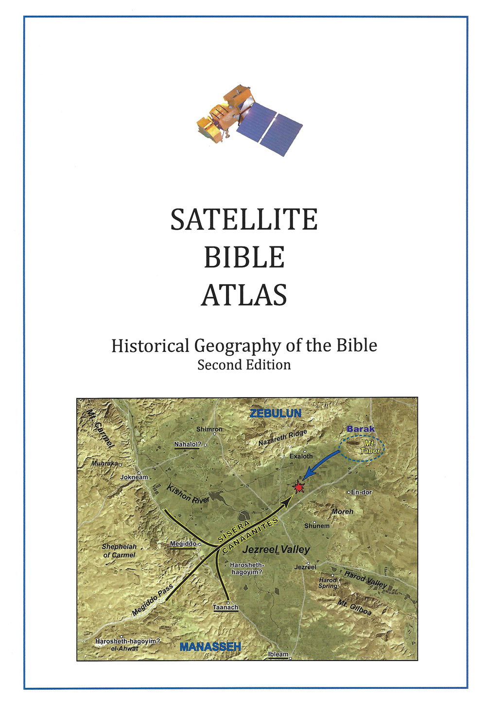
Links
Downloads
Dr. Cyndi Parker
Listen to the Land (Historical Geography)
BS600-06
Coastal Plain and The Negev
Lesson Transcript
All right. So as we come back from the break, we have just finished looking at the Transjordan. And so now we can start moving like we're getting closer and closer to Israelite stories and Israelite context. We're going to start with the coastal plain, but because I like to do reviews and because if I were testing everyone in this class, this, this would be my like this is going to be on the exam table like content. Please make sure you can do this. But just to do a quick just to refresh our memory, we've already seen Bouchon and we saw how it's covered in basalt, so which is going to be our red color. And we have our Dome of Gilead. And although we can nuance this out a little bit, we're just going to call it St Armenian. So it has that red terra rosa soil with almond kind of stuck into this little nook right behind the dome of Gilead. And then we have this plateau area moving down into Moab, both of them being primarily snow neon, which is the red Xena, kind of whitish, chalky ish area. And then off the map, which I keep doing this, which is too bad Edam keeps getting the bad end of the map here. But if we were to go further south into Edam, we're going to be picking up a whole mixture of stones that we see. So we're going to get the scent. Ian But we get the sandstone, we get the sandy nature, and we get the granite mountain hills as well. So now we're going to shift and go over a little bit more to the West.
[00:01:46] So the next really big segment that we're talking about is this southern arena. So the southern portion of the land and just looking at the way that this map is drawn out into segments, unified geological segments in this southern arena, you can see it's quite diverse. We have all kinds of different lines, breaking it into lots of different portions. So we're we're actually going to take this little bit by little bit. So we're going to start on the coastal plain and we're going to work our way around through the biblical Negev and then up along the Dead Sea. And then we're going to deal with the Judean Hill country, because this is going to have so many hearty, meaty stories that have to do with a lot of this hill country area. And also when we get up here to the this northern part of the southern arena, this is where a large portion in a very small band of geography, there's a large portion of Old Testament narratives that happen in that space. So we're we're in for a big major segment here, but we're going to take it just a little bit at a time. We're going to keep in mind. Well, we'll get to that. But we do have the let's go back to that map, because this southern arena contains one of our very enviable east west passageways. So we're going to keep in mind everyone wants this territory. So even when we're not currently dealing with this biblical Negev, we have to know where it is and why everyone wants it and who, how everyone is connected to it. Okay, so let's go to the coastal plain. I'm going to call this the Philistine Coastal Plain because the Philistines lived on this part of the coastal plain.
[00:03:35] So it's fairly descriptive. You will see that in this philistine coastal plain that we have two portions of the international coastal highway that runs through this coastal plain. So we have the one that runs right along the Mediterranean Sea until it gets up here. There's a river that blocks it from continuing to travel north and it pushes the road inland. We have another road that is going to come this way and it hugs the seam between the hill country and the flat coastal plain. And so it stays out of this is the big agricultural zone area. So it stays out of the agriculture, stays on the high road, right at the foothills, and then comes up and we're going to continue this road going up to the north. But it is from this this river up here in all the way down south to the bass or wadi. This is the Philistine Coastal Plain. So when we're looking at the Philistines who arrived in the land roughly at the same time, the Israelites are arriving to the land. So the Philistines were also outsiders to this Canaanite landscape. The Philistines were a more successful people group in terms they were a little bit stronger. So they were able to land in an area where the international road goes through and they have two branches of the international road. So this philistine coastal plain is filled with all kinds of great alluvial soil. So it is soil that is running off for the mountains, being pulled off by the rain. And so soil is getting pulled off and just dumped into this area and this like catchment area. And so you have really thick layers of soil, which makes it really great for agriculture, except when we talk about rules of rainfall, we are to the west, so we should get a decent amount of rain, but we are also very far to the south, which means that we're not getting the massive rainfalls we need for all of the good summer fruits to get the grapes and the figs.
[00:05:52] What we're going to find more is down here on the Philistine Coastal Plain, depending on where you are. We're going to have a lot of grain, lots and lots of barley and wheat, which is interesting because based on some of the historical texts and the pictures we have that were left by the Philistines or depictions of the Philistines by other people groups, we see them drinking beer. And the Israelites were known for drinking wine. But they're in grape country and the Philistines were down here in wheat and barley country, which I just think is kind of a fun little aside. This is the bridge area between Aram Damascus up here in the north and Egypt down here in the south. So there's a whole lot of trade that is coming through. Now, what is an interesting geological complication for the Philistine coastal plain is running along the edge of the Mediterranean. We have these sand dunes and the sand dunes kind of push that road a little bit more inland. And you might notice that, well, since the road isn't going right along the coast, but the coast is almost flat. So there's no good port area. So the Philistines were able to create little areas where little ships could come in and unload goods. But it's not a huge shipping industry. But they definitely engaged in shipping, especially shipping trade with Egypt, which is just over here. So this, you know, for little boats getting into the Mediterranean, hugging the shoreline and coming up, this is a really nice way for trade. It's also going to be the catchment for trade that's coming out of Edam through the Negev and heading out here either to this coastal highway or to the small ships that are in the Mediterranean Sea.
[00:07:52] So we're moving from the Yukon River to the Navajo Bazaar. We have these sand dunes here and we have the higher road here and the Philistines using everything in between and all of the alluvial soil to create agricultural areas. Okay. So what is interesting with this picture is we can see how the sand dunes are creating obstacles. So in this particular picture, I'm just inland. Actually, I'm on one of the primary international roads as I drew it on the map looking towards the Mediterranean Sea. But you can see how even in modern day, this sand dune gets in the way of the flat area right along the Mediterranean. And so it's it it's just enough of a barrier to make it not very convenient, especially if you're there. In ancient times, seeing getting over sand is really quite challenging. And so we can see this effect even in the way that things are built today. How do you build if you're in an area down along the coastal plain and you don't have all that wonderful limestone that you have up in the hills? Well, people down in this area used to use mud brick. And we still have structures that are built with mud brick that is still in existence. Not as many as I would like, unfortunately, because it makes sense. You know, mud is going to dissolve over time and as rain hits it. But any of the areas where they were covered over with debris, some of that mud brick is still in existence. How did people get water primarily out of the wells? So the water table on this philistine coastal plain is quite high. And everyone you can get down to it. You don't necessarily have lots of springs, but, well, water was how everyone access the water that they needed.
[00:09:56] Okay, who are the Philistines? Since we did this with the Ammonites, Moab eight and Edomites, we should say, who are the Philistines? Sometimes they're called the sea people. So we have a people group who come from the area of Macedonia, roughly modern day Greece. Now, some sort of catastrophe, natural catastrophe, maybe. We're actually not really quite sure. Something happened to force people out of their land. And so they seem to come down over to the eastern side of the Mediterranean and then down the entire coast when they get down close to Egypt. In fact, Egypt has on some of their temples, they have depictions of really interesting battles. They fought with the Philistines or the sea peoples. So thinking the Philistines, probably some of them coming with carts laden down with all of their goods, like family homes being moved, not an army out to conquer, but entire families moving. But we have the sea peoples also moving by ship. So they're accustomed to the Mediterranean and and working with the flow of the Mediterranean. And so we have this epic battle that happens with at the Delta where the Nile pours into the Mediterranean Sea. There was a massive conflict between the Egyptians and the sea peoples, and the Egyptians won, but they thought it was a scary enough battle to depict on their temple walls. So Egypt was able to keep them out of Egyptian territory and Egypt kind of pushed them over, like out of our heartland and they ended up settling here. Not all the sea peoples, but a portion of them settle here on this coastal plain and they become the Philistines of the texts that we read about in the Hebrew Bible. They establish for themselves the Anthopoulos. So instead of having one capital city, they have five cities.
[00:12:00] And so we have Akron and Gath. So Akron is the northern one in Gath, so we can see the strategy here. Right there. They're planting themselves on this inland branch of the coastal highway. But then we also have ash died, Ashkelon and Gaza. And so these we can also see there they built their five largest, most significant cities that have their own structure of leadership, but they're all connected as one people group. But we're going to make sure we're holding on to the road. And strategically, they're staying out of the agricultural area at the same time. Okay. Then this kind of comes into play. You may know this story. It's one of the earliest stories of the Israelites. They have already come in and they're in just a small portion of the hill country. The tabernacle is with them at Shiloh and the Philistines are down on the coast. And the Philistines start what ends up being a long history of the Philistines pushing out of the plain, up into the hills. And the Israelites are constantly trying to push them out and push them back. And then the Israelites are trying to get out onto the international road. So there's conflict in between these two people groups. So one of these conflicts very early on happens at Ebenezer, which is where the red kind of star friction star is located. So there's an initial conflict between the Israelites and the Philistines, and the Israelites aren't doing well. And so they go, well, if we use God, who told us that he is the mighty warrior going with us into battle. Let's just go get God who happens to be at Shiloh in the Tabernacle, and let's just bring God into battle with us. You know which God is going to have none of that.
[00:13:54] Right. Like we don't get to use God as a lucky charm in battle, but that's what the Israelites are doing. There's a big conflict and the Israelites lose. And the Israelites go back into the hills and the Philistines go. We have the God of the Israelites. Right. So they take the Ark of the Covenant with them. Now, if we follow, it's really very interesting because Samuel ends for Samuel Chapter five. If we skip around a bit for Samuel, chapter five is going to tell us what happens. So the Philistines took the Ark of God and brought it from Ebenezer, the place of the battle, which notice is out of the traditional philistine. Like we're actually watching the Philistines like push open their territory. So they take the ark from Ebenezer to Ashdod. Well, that's our northern western city where the dot, dot dot is. You know, they place the Ark of the Covenant before their God daggone who ends up falling over in the morning. And everyone's like, What is happening? So they gather the Philistine leaders together and they say, Let the ark of the God of Israel be brought around to Gath. Well, Gath is the southernmost of the inland cities, and at Gath there's just a whole bunch of problems that that that tumors boils like. Everyone is scared. So they pull everyone together. And they sent the Ark of God to Akron. And as the Ark of God came to Akron, the X-ray Knights cried out, saying, They have brought the Ark of God of Israel around to us to kill us and our people. Right. You could see, but this did not work out well for you guys. I don't know why we are the ones who get him next.
[00:15:43] It's at Akron. That too, they end up. Putting the ark, like with a cow that is pulling the ark, and they set the cow free and it turns and makes its way into the whole country. But we can see like this, we could trace the stories of Samson because Samson was constantly in conflict with the Philistines. And Samson, who grows up in this area right here, very close to Aaron, is constantly kind of making this circle through all of the pentathlon cities as as he's pushing around the the Phillips the Philistines. Okay. So we're going to move from Philistine territory and we're going to go a little bit south and we're going to pay attention to that east west connecting band that proves to be very valuable territory. And before we get there, I have to I have to point out to you that this term Negev, it means like to the south. So again, it's a perspective of people who are north who are going negative down in the South. There's different terminology from ancient times to modern day and modern day. If you go to Israel, they call the Negev everything from here all the way down to Eilat. All of it is the Negev. That is not the same as in biblical times, in biblical times, when the Bible talks about the Negev. It's talking about a really small area up here. We're going to hold on to that. We're going to spend more time there. In a moment, we're going to look at what I will call the greater Negev, this area. Although when you look at it, we do have a few cities that are marked on the maps. These cities are beyond the time of the Israelites. It's more like the NABU teens were able to settle in this area, this area by the time you get this far south, even though some areas of it are quite elevated, we're only working with about two inches of rain, which means you can't sustain life because there's nothing you can grow.
[00:17:53] There's not even enough like brush for your animals to really eat, to sustain a shepherding community or a nomadic community. So this is a very difficult area. You have to know exactly where the oasis is and you can only stay there for a short period of time. The Blue Star that I have is on Kadesh Barnea, which you may recognize. The name Kadesh Barnea is one of the places the Israelites stop. In fact, it's where they are when they send off the 12 spies to go spy out the land. It's in Kadesh Barnea, which is an oasis. But you can see how because we're in this, like in between, hard to exist in this kind of terrain. They've not yet hit settled territory. They're not yet in conflict with anyone. So this is definitely there. Okay. Before we get there, what are we getting into? Kind of a decision. And it's here when they make the decision to fear what is ahead of them, instead of trusting Joshua and Caleb that God will be with them as they go. It's at this point that God says basically, all right, turn around and let's hang out here. Let's let's build a little trust. And so in this area, in fact, we have this really nice large wadi area up in here that's called the what is in this Wadi Zin is where the Israelites end up being for a large portion of that wandering for 40 years before they swooped back down to a lot and they come up and around Edam and Moab in this direction. Okay. So the greater Negev also has interesting textures to it. Some people, I think John Munson calls it the knuckles of the negative or the knuckles of the great and terrible wilderness.
[00:19:51] It has four parallel lines of mountains that have been pushed together. And so they they rise up in an otherwise somewhat flat. They create a really amazing texture in this portion of the land where we also get massive erosion craters. Some of the biggest erosion craters in the world are located down here in this great and terrible wilderness. This area. If I were to show you pictures of this area, we get a few watches that have etched their way through this great and terrible wilderness. You can see how dry it is, the evidence of the fact that you get 1 to 2 inches of rain in a place like this. Why this? Maybe you might catch some water and pull it out whenever it does actually rain. We might get a little flash flood and then it very, very quickly goes away. So evidenced by the fact that this little brush can kind of hang out, there had to be water there at some point for that little brush to still exist. And this area, George Adams Smith is one of the the historic explorers of modern day. So in the 1800s, George Adam Smith went and explored this land. He talks about this great and terrible wilderness that is to the south or the greater Negev. And he talks about how every gorge, every valley, bed, every water, a wadi that is dry in the summer and to the ancient traveler seems like a channel of some ancient and forgotten flood is filled annually with a roaring torrent. Some meadows turn it quickly into lakes, but the land is limestone and thus porous heavy rains are quickly drained away and the bodies are left dry and the lakes dwindle to dirty ponds. Which job picks up on, and he uses the exact same imagery to talk about friends.
[00:21:57] My brothers have acted deceitfully like a warty rind. It has to be this southern sort of a wadi, like the torrents of what's which vanish, which are turbid because of ice, into which the snow melts. When they become waterless, they are silent. When it is hot, they vanish from their place. Right? So exploring the this is this kind of greater Negev area. This is the type of imagery that Joe picks up on. Where you might have some texture in certain parts of the Negev in those erosion craters, you might get all the way down to there to the older stone. And so pick up some of the sandstone that shows up at the very, very bottom of the craters. We have little bits and pieces of Jurassic of Rock from the Jurassic time period that is also visible down at the bottom of these craters. Okay. So although this is the place of the wilderness wanderings, we really are interested in where the Israelites ended up settling. So from that, we're going to move a little bit further north and talk about what the Bible is referring to in the Bible talks about the Negev. So in modern day we often say the biblical Negev, because it's when the Bible says Negev, it's this is what it's talking about. People describe it in different ways. It is a little bit has almost a greenish hue on the screen. It's like a an infinity sign. Maybe we're kind of. Bulb's out over here. Pinchas together very close to Beersheba. It still stays pretty narrow, but then it bulb's out on this side. So maybe an infinity sign, maybe a figure eight on its side. It really does kind of open and blend into the southern part of the Philistine Plain.
[00:23:51] So when we get here to Garrard, Garrard is kind of our in between. It's not really the biblical Negev and it's, it's sort of the philistine coastal plain. But this, it kind of opens its way into between these two. It's like a little gateway between these two zones. Okay. So if we were to look at the negative, we've already talked about how it's a depression, which means the hills rise up to the north and the hills rise up to the south. So it is the lowest area. It's quite flat, which makes it really easy for travel, which is why people are always envious of the biblical Negev. It is filled with what we call less soil, which is called it's l0es less soil. Less soil is, is really we only really have it in this particular area. It's quite interesting because it has a lot of Arabian desert sand that has blown in from the east and been deposited in this area. And it's a mixture of that and some of the runoff alluvial soil from the north, less soil has mineral content. So you can raise crops in this area, but you're only getting about ten inches of rain, maybe 12, which is the minimum you need to be able to harvest wheat and barley so you can feel this like we're on the edge, kind of where we're on the edge of the great and terrible wilderness where no one can live. We can coax agriculture out of here, but we need to diversify our interests. And so shepherding is going to be a primary agriculture or industry in this area. Less soil is interesting because it it forms this little mineral layer on the top. And if left unbroken, the soil will not absorb any water.
[00:25:57] And so water that precious, precious ten inches of of rain that you're going to get could hit the crust and just roll away and roll into the waters. And so farmers have to constantly be paying attention to their soil. They have to go through and basically just scratch the top layer to kind of break off that crust so that whenever they do get rain, the rain actually gets into the soil. And then once it does, they actually can produce some sort of harvest. Now we've mentioned or I've mentioned a couple of different times how down in the south we have the Wadi Bissau. So Wadi is the Arabic term for narco, which is the Hebrew term for River or I grew up down in New Mexico. We call them arroyos. You know, any kind of place where water flows, maybe not regularly, but runoff water will flow and collect the base saw. The area I highlighted on the map is all drained by one water system, which is amazing. It's so huge. So it's pulling water from the east and pulling it through the biblical Negev. Whatever little water flows in the greater Negev, it's swooping down and pulling some of that water and pulling it past gorakhpur out towards Gaza into the Mediterranean. So when you look over here, the exit of Wadi Bissau is quite large by where Gaza is. So it has quite a large system now. It also has lots and lots of fingers, which is going to be very interesting in a moment. So just wait. But the fingers are coming off of the hills and pulling water down towards the coast, but there's lots of little branches that are not connected to each other. So I'll try to highlight some of those in a bit, but I want you to see how large and extensive this whole Wadi Bassler system is, and then we'll see how it influences our reading of the text in a moment.
[00:28:17] How do people build in the biblical Negev? Well, you can't use less soil to build. And so like the Philistine Coastal Plain, we're going to use mud brick primarily. Maybe if you're close enough to the hills, you might be able to chop out some of that sand, Armenian limestone and get some of that. But primarily, we see lots and lots of mud brick. If we stand at Be'er Sheva, which is one of our primary Israelite two cities in the biblical Negev, Be'er Sheva is where our infinity sign pinched together is near where Be'er Sheva is. And if we stand at Be'er Sheva, you can see how flat like that seems inviting as a caravan, as either an army or big caravan of traders. This is easy territory to move over. You can see how, even in modern day, they still use this as agricultural land. So you can see how they're they're starting to grow a crop in this area. And we can see we're facing the south in this picture. And you can see how the hills start to rise up again to the south. So it really is creating this nice little and for us pushing people east and west in either direction. In this like thinking of again how Gras is is just out of the biblical Negev, very south of the Philistine coastal plain over here. So we find these ancient stories and we have in Genesis 26. So this is during the time of Isaac. Isaac, who is living most of the time down in the biblical Negev. There was a famine in the land and just think in the biblical Negev, it doesn't take a whole lot for there to be a famine. So there's a famine in the land and most people then would head towards Egypt because Egypt always has fresh water.
[00:30:23] So the biblical writer tells us there's a famine in the land. And then they clarify, besides the previous famine that occurred in the days of Abraham, because there was another famine. And Abraham and Sarah, I went to Garrard, but there's a different famine. So Isaac went to Gura, to Abimelech, king of the Philistines. The Lord appeared to him and said, Do not go down to Egypt. Stay in the land, which I shall tell you. Sojourn in this land. And I will be with you and bless you for. To you and to your descendants. Which is Zechariah is the word descendants, which literally is to your seed. Like to the seed that will become your children. Right to your descendants. I will give all of these lands and I will establish the oath which I swore to your father. Abraham, I will multiply your Zechariah as the stars of heaven and will give to all these lands and by your Zehra. Ha! So we were like, okay, we got it. Like, we're repeating to your seed, to your seed, to your seed. All the nations of the earth shall be blessed. This is sounding a lot like Genesis Chapter 12. Because Abraham obeyed me and kept my charge, my commandments, my statutes and my laws. And then shortly after this, we get an agricultural story. Now, Isaac sowed his seed. It's the exact same word in Hebrew. Except this time we actually it's it maybe it's playing double because we've just repeated your seed, your seed, your seed. Now we're talking about agricultural seed, but it's kind of an interesting. God's promises coming out in reality, like in that same year. So Isaac serves his seed in that land and reaped in the same year 100 fold.
[00:32:30] Which is crazy to think that he planted grains. It would have to have been barley or wheat in the land, in a place where you may not have enough water, where it's really hard to kind of coax something out of the ground where people, farmers would talk about getting 30% returns, 60% return, but 100% return, that's extreme. Isaac gets 100% return on his seed and the Lord bless him, you almost think, oh, is this a foreshadowing of Isaac having his zira ha. That his own seed that is going to reproduce in the land as well. And the man became rich and continued to grow richer until he became very wealthy. Okay. So let's take this and bring in the Wadi Besar And this is a I don't know, a lesson I like to say. What can we learn from a wadi? Because we take them for granted and we don't pay any attention to them. The wadi based source I showed you is draining everything. It's huge, even larger than what's like on the map here. But there's different fingers of the wadi based sword. There's a whole huge network right here, all around garage, and it's draining. There's like a ridge line over here and it's draining all of this ridge line all the way out close to Gaza. There's also another finger of Wadi Baser and it is actually draining water from way up in the hill country near Hebron, all the way down past Be'er Sheva, all the way into the major vein of the Wadi Bay saw, and then up to the Mediterranean. It's also pulling all the way over here from over here in Tel A-Rod, which we're going to look at A-Rod in a moment. It's also pulling water from here all the way out close to Be'er Sheva into the main vein of basalt into the Mediterranean Sea.
[00:34:34] Okay. And I know you're all thinking we don't know why we care about any of this just yet. Turn with me to Genesis 26. And I actually didn't put this. It was too long to fit it all onto a screen. So Genesis 26 is shortly after the passages that we were just reading before. And I'm going to start from verse 16. And read down to 23. Keep your eye on the map as you're following along. And we're going to learn what we can learn from Obeidi. This is really confusing without using a map. So it says. What verse am I starting with? 16, I think then Abimelech. So the king of Gora said to Isaac, Go away from us, for you are too powerful for us. And Isaac departed from there and camped in the valley of Ghajar and settled there so we can see where he's moving. But just outside the city. Then Isaac dug again. The wells of water which had been dug in the days of his father, Abraham, for the Philistines, had stopped them up after the death of Abraham, and he gave them the same names which his father had given him now, which were seeing like this is how people lived in the Philistine Coastal Plain and in the Negev they lived off a well water. And so you can see Isaac is starting to figure out how can I sustain my family in this area? You have to dig a well first. But when Isaac servants dug in the valley and found there a well, a flowing water, the herdsman of grass curled with the herdsman of Isaac saying the water is ours. So he named the well as sick because they contended with him. Then they dug another well and they quarreled over that too.
[00:36:25] So he named it Sidner. He moved away from there and dug another well and they did not quarrel over it. So he named it Rehoboth for he said, at last, the Lord has made room for us and we will be fruitful in the land. Then he went up from there to Be'er Sheva. Okay, so we're looking at a movement from Gaurav to Be'er Sheva and as he goes he digs a well, no, no, no, no, no, no, that's ours. He digs a well. No, no, that's ours. He digs a well, no, no, no that's ours. He digs a well. Oh no. You can have that one. It seems strange, right, until you look at the lady. Because what's happening? He's digging into a water system that is feeding the city of Gras. Like even though he's digging down to the water table, it's all part of the network that is sustaining Gras. And as soon as he gets far enough to the east, they're on a different branch of the Wadi Bay. And so you dig here, the wadi of Gras is no longer in danger. So you dig here? Oh, sure. You can have that water because it's not keeping. It's not making us in danger. So it's interesting, right? Because we're starting to go, oh, they're like they're not just oddly schizophrenic. They actually have a deep, intimate knowledge of the way their land is working. And they're just making sure that Isaac, who seems to be very wealthy and very successful, is not draining their resources over here. Okay. So of course, we have to look at the roads and we have said that in the biblical name is one of the primary international roads that is going across. And so we're going to look.
[00:38:13] Actually, this is interesting, too, if the Israelites are up here. Here's the international road. This is kind of an in-between area. It's like because it's it's really difficult territory to live in all the time. It's very marginal. And you're you're right on the edge of the greater wilderness. And yet, in ancient records, we have Egyptians here, we have Philistines here, we have Edomites here. We have Israelites here. We have everyone here. It's not that they're there because the grain is so good or the grapes are the best we've ever had. You can always say, Why are all those people here? They're here because this is where the international road is, and every blue line on all of our maps will always be the place where wealth is flowing. And so we get everyone here because the wealth of the Negev is down here. Okay. So one of the cities that we're going to pay attention to, because it's a significant Israeli city, is the city of Beersheba. And we have very early records of Abraham being in Be'er Sheva. It's interesting again because Isaiah uses the imagery of the Negev and knowledge that we're down here where it's really dry, we're doing subsistence living and sometimes it's just too dry to grow crops. But this is where the caravans of camels are going to be going between the Mediterranean and Edam and the Arabian Peninsula. And Isaiah's going to pick up on this. And when he is describing or he's borrowing the imagery of the biblical Negev as he talks and he calls this through a land of distress and anguish, from where come the lions and the or the lioness and the lion? They're coming up from Africa as the bears are coming down the Rift Valley from the north, modern day Turkey.
[00:40:14] Vipers and flying serpents. They carry their riches on the backs of young donkeys and their treasures on camels humps. And you just know, if you're living in the biblical Negev, this is what you're seeing all the time, the dangerous animals and then the animals that are just dripping with all the expensive product. One of the first times that we run into Abraham as he is in the biblical Negev, we get this really great story. It's an odd little bit of information. This is Ibrahim planted a tamarisk tree at two Be'er Sheva, and there he called on the name of the Lord, the everlasting God. So one of the first things Abraham does, it Beersheba, is not only does he have a well at Be'er Sheva, but he plants to tree. You that's interesting. And the fact that the biblical writer gives us the detail of a tamarisk tree is also very interesting. There's logic to this, and the logic comes from the fact of what the tamarisk tree is. So the branches look like this. It almost looks like a evergreen tree with little needles. And this is one of my favorite games when I go down for with groups of people is I'll pick like the little sections of the Tamara's tree and I'll just go round and tell and give people some of it and say, Hey, put this in your mouth. If they're university kids, they do it right away. If it's an adult group, they're usually very skeptical. Like, I'm not putting that in my mouth. It kind of depends. But what's interesting is when you put it in your mouth, it is very salty. So this tamarisk tree has all these salt crystals that are in these little branches of the tree.
[00:42:04] Now, that's interesting because salt will absorb water. Right. And so we're in an area that doesn't have a whole lot of moisture. But if you plant to tamra's tree, the salt in the tree will absorb all of the moisture through these little leaves. But by absorbing the moisture, it cools down the air. And so it. Tamara's tree acts like air conditioning. But a natural form of air conditioning. Plus, you get the shade of the tree. So you have Abraham showing up. The first thing he does is planted tamarisk tree, which is providing shade. But it's also kind of going, this is my tree. It's a it's almost reclaiming of the land. It's a very practical thing, which I really love. And then just to tie in one of the stories we touched on earlier when we were talking about where item came from, Genesis 16 is that story where Abraham and Sarah push Hagar out and it says, Now the Angel of the Lord found her by a spring of water in the wilderness by the spring on the way to shore. The way to shore is the road that goes from Be'er Sheva and then cuts this diagonal through the great and terrible wilderness out towards Egypt. Why is she going this way? Because she's Egyptian and she's on her way home, but she's traveling as a single female on her own, extremely vulnerable. And she has to know how to negotiate this terrain or she will never make it back to Egypt. Oh, and here's the there's the root. Let's go back up to Be'er Sheva. After the time of Abraham, Be'er Sheva became a really significant place for the Israelites to control. So when they had a strong enough government where they could reach out of the hills and kind of make their way closer to those international roads, they were able to hold on to Be'er Sheva.
[00:44:05] And then they turned this town that is on the outskirts of the territory that they controlled. They turned it into an administrative town. When we. This is the royal we when archeologists dug here, I often say we feel very at one with them. But when archeologists dug there, they found this really interesting object. This is a very typical Israelite for horned altar. We know they're Israeli. We have them all over the place. We have multiple versions of these this style of altars. What's interesting is we have an altar that was built here in Be'er Sheva. Now, at some point in time, this altar was dismantled and all of the stones were scattered through the rest of the site. The archeologists dug and as they were digging, they actually found one of the stones that's on the corner and has this little snake running up it, which made them think, oh, this has to be something else. And then later they found the stones with that formed the corners. And then they realized, Oh, it was an altar that has been dismantled and the stones put in secondary use somewhere else. So they reconstructed this altar for us. And all it shows us is this southernmost city for the Israelites was an administrative city. It also seemed to be something of a religious hub as well. So maybe a local religious center for people who couldn't get all the way up to Jerusalem. Why was it dismantled? Well, this is when I would look towards the great reforms of Hezekiah and the reforms of Josiah, where they looked through the land and they were like, wow, we're still using all of these altars that are all over the place and we shouldn't be. Let's consolidate everything to Jerusalem and they go and dismantle the altars, potentially.
[00:46:05] Maybe that's why this one in Be'er Sheva was dismantled. It was pulled apart. Now, they're not going to forgo using this stone because it's costly to bring this stone in. And so they're going to use this stone in other building projects. But that could be a sign for us of how people used this city of Be'er Sheva. Okay. Let's go all the way to the far eastern side of our biblical Negev to another very significant city called Arad. What is fascinating about Arad, before we even get to the Israelite stuff, what is fascinating about Arad is thousands of years prior to the Israelites even existing. So prior to Abraham coming from Mesopotamia in the early Bronze Age, the very, very early on, there were a small people group that were able to figure out how to survive in a rod, and they figured out how to survive here in a large enough scale to support agriculture in a very large city. Which is surprising because this land doesn't support it. So we'd have to ask, how did they do it? And I wish I had a great picture aerial shot to show you, but a ride, the ancient site of Arad is actually built on a horseshoe type hill. So where it's flatter around a rod, but there's a rock formation that creates a, you know, the ancient people who lived there before the Israelites built a wall along the top of the horseshoe. And then they kind of etched these channels down into the lowest part in the middle of town, and they collected water in a cistern. And so even though you're only getting 10 to 12 inches of rain, it's rain scattered over a large landmass, trapped inside the wall and funneled all the way down into a like sister in a holding spot in the middle.
[00:48:14] And that was able to sustain the people who lived there for a long period of time. We didn't actually have anyone else who could stay at a rod and create a large city and sustain agriculture in that area. The next very significant architectural remains that we have belonged to the Israelites. Now, the Israelites could not fill up the whole entire space that the early Bronze Age people were able to fill up. The Israelites just took one high portion of that U-shape hill, and they they put and built a fortress up on this high hill. So this is the Israelite fortress. It's been rebuilt several different times. It's high and elevated, which means you can see all over the place because the Negev is nice and flat. So you can see all the way east. You can see the hills of Edam rising up in the distance and you can see almost over to where Be'er Sheva is. Part of the interesting things about this fortress is we found a collection like a library of these portions, which is broken clay, that people are broken pottery that people then take and they use it as a way to scribble down notes and to send it to people. So there's one room in this fortress where there's a whole huge collection of these writing, these writings. They're small, but they're interesting because now what we can do is we can look at who was stationed here, what did they do, what were they keeping track of? And we find that they're keeping track of taxes. So it became another administrative area where people in the surrounding area had to send a certain portion of their wheat and barley here and people from the hill country. If you have like a pretty strong government, they can collect olive oil and wine from the hill country, send it down here, and then this becomes a distribution area.
[00:50:28] There is one small period of time. We think potentially it's during the time of Solomon where this was such a strong fortress and the Israelites were so secure up in the hill country, pushing their way out into these internationally contested areas, that by using these administrative zones, the Israelites were able to go even into the greater Negev and establish a couple of forts along some of the really significant trade routes. But we already said if you are in the greater Negev, you can't survive. There's nothing naturally you can do to survive. Which means this becomes the collection point of goods that get sent to stockpile in these fortresses to help the soldiers survive in that area of the greater wilderness. We also found something else that's really very interesting, and you have to forgive me. I know this is, like really tilted and a little bit weird. This is north looking kind of up towards the Judean hills. And I had to really finagle this so I could try to get this whole building into the shot, this building. Before I tell you what it is, we'll see if you can figure it out. It has three different rooms. It's surrounded by a wall. So it's designated as something different than the whole rest of the fortress. The outer room is quite large, we assume, based on the width of it, that it may have been open aired. As you move through this room, go further into the building. There's a smaller room, this oblong room. And as you move through that, you get to a much smaller room in the back. So it's a tripartite building, which is interesting. It's designated as separate space from everything around it. Let's look at a couple of different objects.
[00:52:33] Keep building out our picture before you guess. In this outdoor area, which may be a courtyard of sorts. We find this very large square piece. It has a channel that runs down the side of it. So it's something it was outlined by cut stones but made out of field stones on the inside. So that's an interesting object out here. When we move in to this oblong, this like rectangular room here, as we pass from this room to this one, we have two incense, altars that are standing here at the opening to the door. And then once you get in here now, this interpretation has changed over the years, which has been fun to watch. But let's say there's one standing stone back here. It's a stone that is obviously very different from every other stone in this area. All right, so what is this place? Three rooms. Tripartite building. Each room getting successfully smaller. The Holy of holies, not the whole thing. But this might be the holy of holies, representing the holy of holies. It has a tabernacle slash temple. Shape to it with an alter in the air like out so designated space with an alter. You move into where the the the holy space is and in the holy of holies back here. Now, this is interesting. When it was first found, there were two standing stones. This is a little bit of the geeky like interpretation has changed over time because there were two standing stones, a big one and a small one. And that became problematic because this is obviously an Israelite temple of sorts. It's in the Israelite fortress and it dates to the time of Solomon or just after Solomon. And so it is on the exact same ratio as the temple in Jerusalem.
[00:54:32] It's just smaller, but the buildings have the same ratio. So in an Israelite structure, why are there two stones in the back that are standing stones? And there's interesting, like, you know, we can play with interpretation of that. But what has happened over the years is one of the stones has disappeared. And this has happened in the Israelite Museum, in the actual archeological site itself. One of the stones has been absorbed into the back wall, which is very different from the way it was found. If you look at the oldest archeological magazines and all of the original ways it was found, it just became so problematic to have two stones back here in the place that is the holy of holies. So what do you do with that? It's just easier if you get rid of one of the stones. Right. Which has happened over time. So I have pictures of this temple in all of the different phases, which is which is kind of fun. Okay. What is the temple doing in A-Rod? That's the big question. It's a little bit like finding an altar at Be'er Sheva. You have two very large, very important administrative cities at the edges of the Israelite kingdom, far away from Jerusalem. They're marking the edge of Israelite territory. What they're able to control. Maybe some people will say it provides a religious center for people who are there because they can't make it to Jerusalem all the time. And so this stands in as a representative. This like the altar in Be'er Sheva is going to get destroyed and is no longer used as the fortress goes through all of its different manifestations. So we then also see in Arad a transformation like a reformation that is happening within an Israelite city where there is some sort of sacred complex that is here.
[00:56:32] And then the importance and sacredness of this complex disappears. But we still have evidence of it being here. But it just speaks to the significance of this area and how the town of Arad was so important for the Israelite people. Okay. We might be able to play into this a little bit more and understand what is maybe background context to another story. This is in First Kings ten. This is when we meet the Queen of Sheba. The Queen of Sheba lives down by the Red Sea. So she's very far south, maybe south of Egypt. Some people sometimes put her in the modern day Arabian Peninsula, but usually south of Egypt is where we say Sheba is. So the Queen of Sheba, we see her coming to visit. Solomon So Solomon is up in the hill country in Jerusalem. Now, when the Queen of Sheba heard about the famous Solomon concerning the name of the Lord, she came to test him with difficult questions. And again, we're going to say this is a theological text, right? It's giving us the theological background to who Solomon is as a man of wisdom given by God. But we're going to use our maps to kind of go what else is also happening at the same time? So the Queen of Sheba comes. And she has to travel all the way from the Red Sea down in the Negev, all the way up to Jerusalem, which means she has to come up the Arava or the Rift Valley. She's going to have to go through the Negev or at least get to a ride and then maybe take one of the roads that goes up to Hebron and then up to Jerusalem up here. So that's quite a far distance for her to go there.
[00:58:25] She has to be motivated by something and we can see the goods that she is bringing. So she goes to Jerusalem with a very large retinue with camels carrying spices and very much gold and precious stones. Those are the resources down of the south. She gave the King 120 talents of gold and a very great amount of spices and precious stones. Never again did such abundance of spices come in as that to which the Queen of Sheba gave to King Solomon. Now the story goes on as she kind of inspects his wisdom. But this is where I like to say, why is she there? Why is the Queen of Sheba going all the way up to people who live in the hills? Now, this is where it's really good to know there's an altar in Be'er Sheva. There's a temple in a rod. The Israelites have firm control of this, potentially a network of forts at the same time down here. Why is the Queen of Sheba going to visit Solomon? Solomon happens to control all the trade. If the Queen of Sheba wants to get her goods over here to the Mediterranean, she's going to have to pass through Solomon's territory no matter which way she goes. Solomon has control over all of the networks in the South. So why is she in Jerusalem? She's probably likely negotiating trade deals, and she's giving Solomon a taste of what is going to end up coming through his country on the backs of camels. And Solomon makes some sort of deal with her, which we don't have the deal, which is too bad. But then let's kind of expand our view and say, why is Solomon one of the richest of the Israelite kings? There's no other king in Israeli history who controlled the amount of trade that Solomon did.
[01:00:27] So, of course, he's going to be one of the richest, one of the wealthiest, most of the well controlled of the kings of Israel. Like Kingdom was so strong during the time of Solomon. And one more thing we should keep in mind. We're going to see this maybe on the very, very end of our time together item as we move to the end of Israelite history. Well, even all through Israelite history, Edam was always jealous of this biblical Negev. We find Edam also trying to be here. And why? Well, because Gaza is right over there. It's Mediterranean trade, because this is so significant and wealthy, because it makes a nice connection for all the trade there absorbing into their country. So this becomes a really nice connection. They're always trying to get over there. It's like a constant conflict between brothers. Right. It's like, you know, butting heads against each other all the time. We have when the kingdom has already split Israelite kingdoms, split Northern Kingdom of Israel is taken away into slavery by Assyria. Southern Kingdom of Judah falls to Babylon. When Babylon comes to take Judah, the Edomites make an agreement with Babylon, they basically surrender to Babylon. And they say, By the way, we will form a blockade here so that no Israelites can escape to the South. So when Babylon attacked from the North, it attacked from the south. And in return, Itamar got all of this land. So when the Israelites were taken away into slavery. Edam moves over and stretches their world influence into this area. By the time we get to the Israelites coming back now, we can call them Jews, and they come back to the land of Judea. And by the time we get to.
[01:02:28] Let's call it the time of Jesus first century. We have an important ruler whose name is Herod. Sometimes Herod the Great. Herod the Great is an Adomian. What does that mean? He is of a descendant of Edam that has moved over to this land, has settled here, and this is where he is when he was born in Adomian, in this area, representing a history that is quite problematic for the Jews later on. So it's an interesting tidbit to kind of know what happened through the years. Where did people come from? Because we're going to meet Herod the Great in a little bit more substantial way later on. Okay. I'm going to pause just for a second, because that was a lot of information as we did the Philistines, coastal plain, the greater Negev and the Biblical Negev. And let's just see if there's any questions from anyone. So when you're talking about how the Philistines came to be where they were, they had migrated into that area. And then we think about the Israelites starting out there and then going to Egypt and then coming back. Yeah. And sometimes maybe people think, well, there was established populations in these areas and the Israelites were the foreigners, but actually they were related to the Edomites. The more bites the Ammonites and those people were changing places too. It doesn't seem like there was established populations and the Israelites were coming in as foreigners and pushing everybody out. It's like these places were fluid. Hmm. I think things are moving around from time to time. Yeah. Different populations were. Were moving depending on what was going on politically and economically. Yeah. Which is is true to a certain extent. You know, when we talk about the Israelites going into the land of Canaan.
[01:04:31] I mean, Keenan isn't and we talk about Canaanites, but that's not a unified people group. That is a collection of lots of different peoples who were living in that land. So maybe they weren't all as migratory as Israel had been and absent from the land. But Israel had a rich history in the land as well. So some people, especially when they're talking about the philosophy of theology of place, we'll talk about the Israelites when they come back to the land and are entering for the first time from the plains of Moab. And yes, they've had to pass around. People like the Edomites have been there for a while and Moab has been there for a while. There are a lot more established were the Israelites had left, like the descendants of Abraham and Jacob had left. They're moving back into a land where Abraham, Isaac and Jacob did not actually own big swaths of Canaanite land either, like they had been migratory through that land. But there had to be an aspect of the Israelites coming into the land where it's a homecoming of sorts. Not for them, actually, but they've heard stories like they have patriarchal stories of Abraham and Sarah and Isaac and Rebecca. Like we have these stories that are that are in this land, that are in the soil and rocks of this land. So it's a homecoming of sorts, but it's also a homesteading of sorts. It's a we have to go in and clear the land. We have to go in and do the work of being here. But it is interesting because we can see how their their understanding, their relationship to other people, groups. Which ones are they related to and which ones are they not related to? The different Canaanite peoples that are there and they're not related to the Philistines either.
[01:06:24] Yeah. And even when they go in and God says, don't marry like all the Canaanites, but there's no restriction to marry Philistines. The Philistines were outsiders just as much as the Israelites were outsiders coming in. So it's kind of an interesting little detail that is that we don't always pick up on. But yeah, it's, it's, it is interesting to kind of look at where they have memory, where they have history and where they don't. I'm curious, the imagery. It's someone 26 four where it says restore our forces like the streams of their naked. Hmm. So what is what where are they trying to create? What's the picture there? Because we're talking about a dry body that becomes charged. So what is the picture there? Yeah, it's good. It's playing on the image of the wadi, flooding with water and then nourishing all this greenery. And so even if it goes away, there's a. Let's recharge, just like when the waters flow through the Negev. So it's a wadi or the waters of the Negev. The the wadi through the Negev is a favorite kind of metaphor that the biblical writers play on. So we could we could use lots of those. There's there's another psalm that talks about it's a Davidic psalm. The Jews use it a lot to talk about the feeling of what people would feel like, who went away into exile, who are coming back to their land. But it's playing on the imagery of the Negev of when things are hard in the Negev. Do you eat your seed or do you grow your seed? Right. So there's a a going out through the Negev for the last time, scattering seed and weeping as they go.